Ocean Data
 NOAA Ocean Data Education Project NOAA Ocean Data Education Project
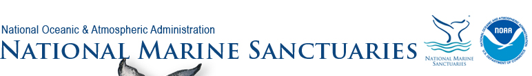
The NOAA Ocean Data Education (NODE) Project is developing curriculum for grades 5-8 designed to help teachers and students use real scientific data to explore dynamic Earth processes and understand the impact of environmental events on a regional or global scale. Explore a curriculum module to learn about El Niño using real NOAA data.
 Winged Ambassadors Winged Ambassadors
Albatrosses-charismatic and threatened seabirds-are ambassadors for a clean ocean. They traverse vast oceanic regions searching for floating food. Along their journeys, they ingest plastic trash and are hooked in fisheries. These five lessons use inquiry-based science instruction, aligned to standards for grades 6 - 8 with extensions for grades 9 - 12.
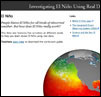
 Animals in Curriculum-based Ecosystem Studies (ACES) Program Animals in Curriculum-based Ecosystem Studies (ACES) Program
Are you interested in tracking ocean animals live in your classroom? ACES is an important, necessary expansion of Signals of Spring, an award-winning, classroom based curriculum program in which students use Earth imagery to explain the movement of animals that are tracked by NOAA's operational satellites. Students will study aspects of the animal's life history, conservation status, food web, and connections to ocean processes and remote sensing data.
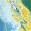 Ask SIMoN Ask SIMoN
SIMoN: the Sanctuary Integrated Monitoring Network is a long-term program that takes an ecosystem approach to identify and understand changes to the Monterey Bay National Marine Sanctuary. Browse the website for lots of exciting data and images that your students can work with.
|